Security
Sensing the surroundings: Blickfeld’s LiDAR technology
Frankie Youd speaks to Blickfeld’s co-founder and chief experience officer, Dr Florian Petit, to find out more about how the company's LiDAR solution can help airport security.
Today’s airport security is usually a complex system that involves numerous sensors and additional technology for it to work to maximum efficiency. However, these systems are susceptible to error, can be affected by the weather, and have high running costs.
Crowd management and control in airports is key to not only guaranteeing customer satisfaction and reducing long lines, but also to ensuring security is always upheld. Paired with this, the Covid-19 pandemic has made the issue of social distancing a key factor in crowded environments such as airport terminals.
With this issue in mind, start-up Blickfeld has been working on light detection and ranging (LiDAR) sensor technology, which can create 3D images of airport surroundings.
Utilising laser-based technology, the images provide the airport with accurate data on the number of passengers in certain areas – allowing for a more controlled secure airport process.
Frankie Youd: Could you provide some background on the company?
Dr Florian Petit: Founded in 2017 by myself, Mathias Müller, and Rolf Wojtech, Blickfeld is a fast-growing start-up with over 130 employees that develops revolutionary LiDAR sensor technology including hardware and software solutions.
Blickfeld pursues a novel approach to building LiDAR systems for the environmental perception of autonomous machines, as well as many industrial applications.
Blickfeld has developed a unique technology based on a patented micro-electromechanical systems (MEMS) scanner technology, which merges the best of both silicon microfabrication and already established LiDAR concepts.
This advanced approach closes the gap between today’s high-cost systems and the automotive mass market needs, enabling safe and affordable autonomous transportation along with further tracking, processing, and management capabilities.
The unique integration of proprietary reliable, accurate sensing technology and cutting-edge perception software, combined with ‘smart LiDARs’, adds benefits to countless industries and opens the field to completely new and fast-growing application areas, such as people counting and volume measurement capabilities.
Our ‘smart LiDARs’, are extremely flexible and practical to use, as they can be adapted into an extensive array of use cases from a simple mouse click. Parameters such as the field of a particular view, the resolution or specific points of interest can be adjusted by software and thereby easily converted into variating mounting points.
How does the technology work?
LiDAR sensors use laser technology to capture both the environment and the objects within these spaces, in reliable and accurate three-dimensional ways.
Blickfeld’s LiDAR capabilities depict the scene by using a laser-based measurement system, which emits thousands – or even millions – of laser pulses per second and recollects these after they have been reflected by surrounding objects.
The time that elapses between emission and detection – time-of-flight – allows for these objects to be located in real-time, accurate to within a centimetre.
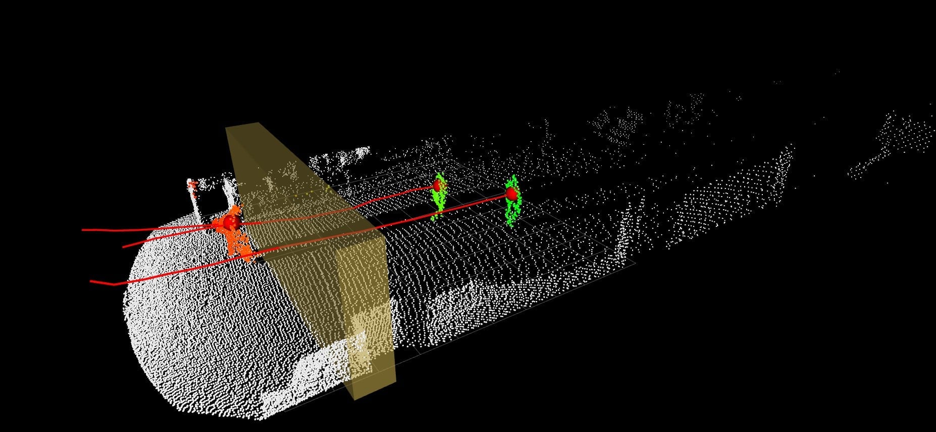
From these detected data points, a so-called ‘point cloud’ is created, in which the setting is mapped in detail. Each point corresponds to a distance value from the detected subject, where the distances in between these objects can be read from the colour values provided.
This point-cloud data is transmitted to the airport’s IT system in real-time, where our very own Percept software digests and interprets information so people’s movement in an area can be detected, classified, and counted.
In the near future, the Percept software will no longer require an external computer. At CES 2022, we introduced the smart LiDAR Qb2, where Percept is able to run directly on the device – eliminating the need for external computers altogether. We will be shipping the first prototypes during mid-2022.

Point cloud recorded with Cube 1 at Frankfurt Airport, yellow barrier marks counting zone
How could the technology help with security at airports?
Today’s security systems can be very complex and tend to include a variety of different types of additional sensors. Nevertheless, the systems used have weaknesses, such as high susceptibility for error, high installation and maintenance costs, sensitivity to weather conditions and limited or no functionality in the dark.
The use of 3D LiDAR sensors helps to overcome these weaknesses and greatly improves the effectiveness and reliability of the entire system at hand. Blickfeld’s LiDAR offerings are extremely practical to use within airport spaces, as our sensors can be mounted in flexible ways.
They do not have to face top-down, but can be installed so they are pointing across an array of various directions. With regards to further security checking processes, our technology detects, counts, and tracks people’s movement patterns.
With this, the intrusion of unauthorised people accessing high-security areas can also be captured, as Blickfeld’s technology makes perimeter intrusion detection systems much more efficient.
Our Percept software manages to deliver actionable data by creating a list of the detected objects, ultimately enabling airport managers to make the right decisions right away.
By processing the information collected by Percept, airport workers are able to understand the number of employees needed at security checkpoints, based on real-time data that is collected from the number of passengers heading to any given gate, for example.
What are the benefits of using MEMS and LiDAR?
Blickfeld’s sensor offerings are based on advanced proprietary MEMS semiconductor technologies that are more adaptive, more powerful, smaller, and cheaper to manufacture than mechanically scanning LiDARs.
MEMS combines logic elements and micromechanical structures in a single chip. Blickfeld’s MEMS provides high resolution, a long detection range, and a wide field of view.
An advantage of Blickfeld’s proprietary silicon MEMS-based 3D LiDAR solutions is that they are software-definable smart LiDARs. This means that our sensors are adaptable for other uses through the click of the mouse – there is no need to change the hardware at all.
Parameters such as the field of view, resolution, or points of interest can be adjusted by software and thereby easily adapted to variating mounting points. This makes Blickfeld LiDARs extremely flexible and inexpensive to use.
Our LiDAR systems also ensure a straightforward setup and configuration process when using our web-based user interface (WebGUI) for various types of counting zones.
What’s more, the sensors enable precise counting and tracking of people and objects with 3D coordinates, with movement paths being able to be tracked and displayed in real-time in digital twins. A large coverage area can be captured here due to the long-range and wide field of view.
Ultimately, multiple hundreds of square metres can be covered by only one of our sensors, proving to be thus very cost efficient. If larger areas are needed, the data from multiple field-of-view Blickfeld LiDAR sensors can also be easily merged through our very own WebGUI, combining the data pulled from several sensors together.

Blickfeld LiDAR equipment at check-in hall A of Frankfurt Terminal 1 for Fraport AG
How is this an improvement on the technology being used currently?
In comparison to other sensor technologies, Blickfeld’s LiDAR offers key advantages in terms of range, detail, and reliability, with hacking accessibilities proving to be near impossible.
LiDAR technology has great advantages in difficult lighting and many weather conditions, including darkness, snow, rain, or even strong sunlight. With this in mind, our software and hardware LiDAR capabilities are highly robust when it comes to environmental conditions, such as lighting or strong winds, providing reliable and highly accurate results through an array of conditions.
What’s more, LiDAR can also operate in the dark, meaning it can provide continuous and real-time measurement even during the night – allowing for 24/7 monitoring in all areas of the airport. Given its extensive range and limited need for moving mechanical parts, the information needed at any point can be collected from a safe distance, without endangering the safety of the workers.
The ability to undertake multiple-point scanning makes LiDAR perfect amongst the every-day hustle and bustle of airport spaces. This also predestines LiDAR sensors for use in advanced security technologies, such as custom digital boundaries or fenceless barriers.
Additionally, as a silent and discreet device with an elegant design, these have no similarities to other devices such as cameras, which although common in airports, may raise suspicion in obvious ways.
Do you think this could be the future for airport security technology?
LiDAR technology enables more efficient security processes through several different applications, which will play an increasingly important role in airport settings in the future.
LiDAR sensors are installed throughout these public spaces to complement existing technologies by compensating for their weaknesses. This piece of tech is particularly useful when tracking objects and calculating 3D data, as, unlike cameras, LiDAR sensors directly capture environments and areas in three dimensions, ultimately achieving a very high accuracy and low susceptibility to error.
Another reason I believe LiDAR hugely benefits airport spaces and security processes as we move into the future, is the technology’s capability of preserving people’s privacy at all times.
Our 3D hardware and software offers a new dimension of precision given the versatility of the sensors, which ultimately ensures absolute anonymity given no image is captured, whereby people are detected, not identified. Essentially, a great point of benefit as privacy requirements are fulfilled amongst these spaces.
Main image: Blickfeld co-founder and chief experience officer, Dr Florian Petit.
All images credit: Blickfeld